Ngāti Hei is recognised as the dominant tribe of the Mercury Bay area and can trace its roots to the arrival of the Arawa canoe at Maketu around 1350AD. Hei was an esteemed spiritual elder on the canoe that set sail from Rangiatea on the Tahitian Island of Raiatea. Hei travelled North to Moehau on the Coromandel Peninsula before returning to Maketu. It is significant that the stream that flows into Buffalo Beach is called Taputapuatea, the name of the sacred marae the Arawa left from all those years ago.
Ngāti Hei were reputed to be peaceable seafaring people. Unfortunately throughout history they endured much suffering at the hands of raiding parties who repeatedly stripped Ngāti Hei of their assets and slaughtered them with muskets. The tribe’s strategic location made it a target for raiding parties paddling up and down the east coast. In the 17th century, land was lost through assimilation, escalating to more hostile raids in the 18th and 19th centuries.
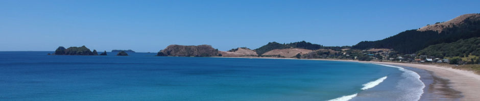
On November 12, 1769, the first written account of a pōwhiri between Māori and Pākehā occured when Captain Cook was invited to Wharetāewa Pā at Wharekaho in Whitianga. Cook and his crew, including the Tahitian Navigator Tupaia, spent 12 days at Te Whanganui a Hei. Cook spent his time there measuring the transit of Mercury across the sun, trading and resupplying his ship in what was described as an amicable cultural exchange with Ngāti Hei. But within 50 years, Ngāti Hei’s numbers would be decimated to less than 100 – due to disease and a devastating invasion by Ngāpuhi with their newly acquired muskets. Hostilities continued unabated from 1769 to 1838 when peace was finally made with the Ngāpuhi.
Historical Background to the Treaty Claims of Ngāti Hei
In 1836 and 1837, a timber trader made agreements with Ngāti Hei rangatira over lands on either side of the Ounuora River. In 1839, another trader negotiated a land transaction for an area around Tairua. Both claims were investigated by the Land Claims Commission. There were anomalies in the evidence presented to the Commission. The boundaries of the transactions and the goods given in payment to Māori were sometimes unclear. After accepting the commissioners’ recommendations, the Crown awarded almost 7000 acres of land in which Ngāti Hei had interests to European claimants. As a result, Ngāti Hei lost much of their coastal whenua.
Between 1858 and 1865, the Crown purchased Ahuahu from other Hauraki iwi. There is no evidence that Ngāti Hei were consulted about this purchase or that they received payment for their customary interests in the island.
Between 1859 and 1865, the Crown bought over 20,000 acres of land in the Ngāti Hei rohe. The Crown did not provide reserves for Ngāti Hei; nor did it require any assessment as to whether Ngāti Hei retained adequate land for their needs.
Between 1870 and 1890, 15 large blocks of 1000 acres or more, totalling over 93,000 acres, were permanently alienated from Ngāti Hei. The Crown purchased 12 of these blocks, over 81,000 acres in total.
In 1885, the Ngāti Hei owners of Kuaotunu 3 entered into a lease arrangement with a timber felling company. The owners considered that the lease gave the company only the right to harvest timber. The owners claimed that the company had deliberately misled them over the contents of the lease, which included rights to land. The timber company took its case to the Validation Court in 1895. Ngāti Hei incurred considerable costs attending the court hearing in Auckland. The court rejected the timber company’s case. At the same time, the Crown was in the process of purchasing interests in Kuaotunu 3. The Crown refused to give Ngāti Hei a reserve at Te Whauwhau, partly on the basis that there had been no reserve granted in the lease, despite the lease having no legal standing.
There has been a history of extractive industry in the Ngāti Hei rohe, including kauri logging, kauri gum digging, flax milling, gold mining, and fishing. Ngāti Hei have derived little long-term benefit from these industries, and the damage done to the environment in their rohe is a source of grievance for them.
In 1923, Ngawhira Tanui of Ngāti Hei wrote to the Crown to ask for a survey of Ohinau Island for the purpose of taking her claims for ownership to the Native Land Court. The Crown reacted by delaying the Native Land Court hearings while it surveyed the island and took it under the Public Works Act 1908. Although the Crown needed only a small part of the land for a lighthouse, it acquired the whole 72-acre island.
By the end of the 20th century, Ngāti Hei were virtually landless. The resulting marginalisation of Ngāti Hei, including loss of te reo Māori, educational underachievement, sickness, and socioeconomic deprivation, caused the iwi much suffering. The Crown’s discouragement of te reo Māori, along with the fragmentation of Ngāti Hei tribal structures and the migration from ancestral lands, severely affected Ngāti Hei’s ability to pass mātauranga Māori on to their mokopuna.
Later came European colonists with their timber trade, the gold rush, gum digging, and a hunger for land. Apart from turangawaewae land at Wharekaho, the only other land retained until relatively recent times (1930) was parts of Kauanga-Whenuakite. Ohinau Island – taken by the Crown in 1923 without investigation of title in the Maori Land Court – was finally returned to Ngāti Hei in February 1995.
Cultural Redress
The cultural redress package for Ngāti Hei intends to recognise the traditional, historical, cultural and spiritual associations of Ngāti Hei with places and sites owned by the Crown within their area of interest. It includes:
- Fifteen sites of cultural significance will be vested in fee simple in Ngāti Hei. Some of the properties will be included as part of the Hauraki Gulf Marine Park
- Two sites jointly vested in Ngāti Hei and other iwi
- Within two years from settlement date, Te Karaka will be vested in the Ngāti Hei governance entity who will vest it back 30 days later to the Crown for the people of New Zealand
- Within one year from settlement date, Repanga (Cuvier) Island Nature Reserve will be vested jointly in the governance entities of Ngāti Hei, Ngāti Maru, Ngāti Tamaterā and Ngaati Whanaunga who will vest it back seven days later to the Crown for the people of New Zealand
- A statutory acknowledgement over fifteen areas, including designated reserves, rivers, streams and the Whangapoua Forest Conservation area. This recognises the association between Ngāti Hei and the designated sites or areas and enhances the ability of the iwi to participate in specified resource management processes
The settlement also provides for the following official geographic name changes:
- Castle Island to Castle Island/Ngātūturu
- Rabbit Island (in Opito Bay) to Motu-o-Whairaka/Rabbit Island
- Rabbit Island (off Slipper Island) to Waikaiā/Rabbit Island
- Grahams Stream to Waitoko Stream
- Wigmore Stream to Ko Tahuri-ki-te-Rangi Stream, and
- The Twins (Motumanga) to Motumāhanga/The Twins
In 2019, Ngāti Hei hosted a flotilla of Waka, Va’a, heritage ships and their crews along with dignitaries and the Coromandel community as part of the Tuia 250 commemorations. They saw it as an important step towards reestablishing themselves, as a strong and prosperous iwi.